Thank you for supporting this site ❤️
Make a donation
Make a donation
Gear up for your next adventure:
As an Amazon Associate, this site earns from qualifying purchases at no extra cost to you.
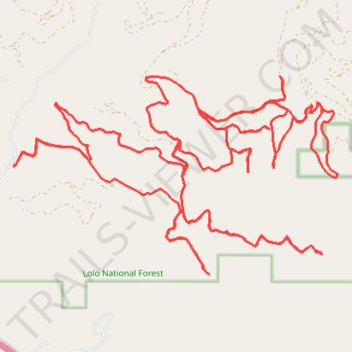
Black cat gulch
- Distance: 25.2 mi
- Elevation gain: 4,354 ft
- Maximum elevation: 5,623 ft
- Elevation loss: 4,357 ft
- Minimum elevation: 3,255 ft
- Moving time: 3 h 49 m
- Moving speed: 6.6 mph
- Maximum speed: 30.6 mph
- Total time: 4 h 43 m
- Global speed: 5.3 mph
Interactive trail map
Thank you for supporting this site ❤️
Make a donation
Make a donation
Gear up for your next adventure:
As an Amazon Associate, this site earns from qualifying purchases at no extra cost to you.
Trail profile
- Distance: 25.2 mi
- Elevation gain: 4,354 ft
- Maximum elevation: 5,623 ft
- Elevation loss: 4,357 ft
- Minimum elevation: 3,255 ft
- Moving time: 3 h 49 m
- Moving speed: 6.6 mph
- Maximum speed: 30.6 mph
- Total time: 4 h 43 m
- Global speed: 5.3 mph
Thank you for supporting this site ❤️
Make a donation
Make a donation
Gear up for your next adventure:
As an Amazon Associate, this site earns from qualifying purchases at no extra cost to you.
About this trail
Name: Black cat gulch trail, distance, elevation, map, profile, GPS track
Start: Black Cat Gulch Road, Missoula County, Montana, United States (47.02392 -114.19692)
End: Black Cat Gulch Road, Missoula County, Montana, United States (47.02390 -114.19695)
Coordinates: 47.00894 -114.19695 47.03629 -114.13174
Topography: Missoula County topographic map, elevation, terrain
Thank you for supporting this site ❤️
Make a donation
Make a donation
Gear up for your next adventure:
As an Amazon Associate, this site earns from qualifying purchases at no extra cost to you.