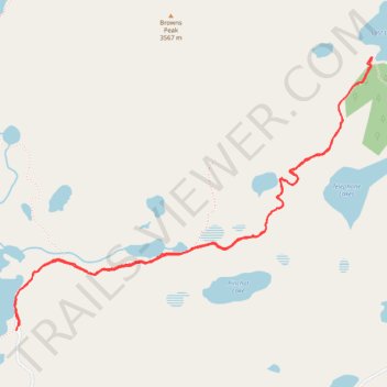
Lost Lake via Lost-Glacier Lakes Trail
Hiking
- Distance: 4.2 mi
- Elevation gain: 502 ft
- Maximum elevation: 10,951 ft
- Elevation loss: 505 ft
- Minimum elevation: 10,761 ft
- Moving time: 1 h 54 m
- Moving speed: 2.2 mph
- Maximum speed: 3.4 mph
- Total time: 2 h 28 m
- Global speed: 1.7 mph
Interactive trail map
Trail profile
- Distance: 4.2 mi
- Elevation gain: 502 ft
- Maximum elevation: 10,951 ft
- Elevation loss: 505 ft
- Minimum elevation: 10,761 ft
- Moving time: 1 h 54 m
- Moving speed: 2.2 mph
- Maximum speed: 3.4 mph
- Total time: 2 h 28 m
- Global speed: 1.7 mph
About this trail
Name: Lost Lake via Lost-Glacier Lakes Trail trail, distance, elevation, map, profile, GPS track
Start: Gap Lakes Trail, Albany County, Wyoming, United States (41.35831 -106.29448)
End: Gap Lakes Trail, Albany County, Wyoming, United States (41.35811 -106.29463)
Coordinates: 41.35811 -106.29476 41.37204 -106.27045
Topography: Albany County topographic map, elevation, terrain