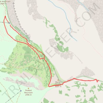
Trail from Grand Targhee Resort to viewpoint and trail to Teton Canyon trail
- Distance: 3.5 mi
- Elevation gain: 991 ft
- Maximum elevation: 9,849 ft
- Elevation loss: 1,014 ft
- Minimum elevation: 9,409 ft
- Moving time: 2 h 45 m
- Moving speed: 1.3 mph
- Maximum speed: 2.6 mph
- Total time: 5 h 44 m
- Global speed: 0.6 mph
Interactive trail map
Trail profile
- Distance: 3.5 mi
- Elevation gain: 991 ft
- Maximum elevation: 9,849 ft
- Elevation loss: 1,014 ft
- Minimum elevation: 9,409 ft
- Moving time: 2 h 45 m
- Moving speed: 1.3 mph
- Maximum speed: 2.6 mph
- Total time: 5 h 44 m
- Global speed: 0.6 mph
About this trail
Name: Trail from Grand Targhee Resort to viewpoint and trail to Teton Canyon trail trail, distance, elevation, map, profile, GPS track
Start: Fred's Mountain Summit Trail, Teton County, Wyoming, United States (43.78676 -110.93423)
End: Blondie, Teton County, Wyoming, United States (43.78720 -110.93468)
Coordinates: 43.77643 -110.93565 43.78821 -110.91363
Topography: Teton County topographic map, elevation, terrain