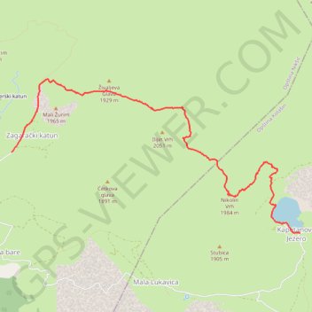
Kapetanovo jezero - Zagarački Katun - Ilijin i Nikolin Vrh
- Distance: 4.7 mi
- Elevation gain: 1,594 ft
- Maximum elevation: 6,693 ft
- Elevation loss: 1,444 ft
- Minimum elevation: 5,384 ft
- Moving time: 3 h 19 m
- Moving speed: 1.4 mph
- Maximum speed: 4.2 mph
- Total time: 5 h 50 m
- Global speed: 0.8 mph
Interactive trail map
Trail profile
- Distance: 4.7 mi
- Elevation gain: 1,594 ft
- Maximum elevation: 6,693 ft
- Elevation loss: 1,444 ft
- Minimum elevation: 5,384 ft
- Moving time: 3 h 19 m
- Moving speed: 1.4 mph
- Maximum speed: 4.2 mph
- Total time: 5 h 50 m
- Global speed: 0.8 mph
About this trail
Name: Kapetanovo jezero - Zagarački Katun - Ilijin i Nikolin Vrh trail, distance, elevation, map, profile, GPS track
Start: Piperski katun, Bojovića bare, Nikšić Municipality, Montenegro (42.82157 19.18699)
End: Kapetanovo Jezero, Kolašin Municipality, Montenegro (42.81188 19.23360)
Coordinates: 42.81188 19.18699 42.83023 19.23360
Other hiking, mountain biking, running and outdoor activity trails
Click on a trail to view its statistics, map and profile.
Lukavica - Velje Duboko - Mrtvica
Montenegro > Nikšić Municipality > Bojovića bare > Piperski katun
Distance: 18.9 mi • Elevation gain: 5,282 ft • Maximum elevation: 5,925 ft
2022_Yu
Slovenia > Ajdovščina > Žapuže
Distance: 1,526.9 mi • Elevation gain: 105,144 ft • Maximum elevation: 6,398 ft