Thank you for supporting this site ❤️
Make a donation
Make a donation
Gear up for your next adventure:
As an Amazon Associate, this site earns from qualifying purchases at no extra cost to you.
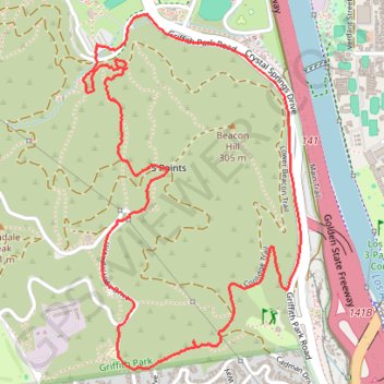
Griffith Park
Morning Hike
- Distance: 3.5 mi
- Elevation gain: 758 ft
- Maximum elevation: 1,066 ft
- Elevation loss: 761 ft
- Minimum elevation: 453 ft
- Moving time: 1 h 14 m
- Moving speed: 2.8 mph
- Maximum speed: 4.5 mph
- Total time: 1 h 24 m
- Global speed: 2.5 mph
Interactive trail map
Thank you for supporting this site ❤️
Make a donation
Make a donation
Gear up for your next adventure:
As an Amazon Associate, this site earns from qualifying purchases at no extra cost to you.
Trail profile
- Distance: 3.5 mi
- Elevation gain: 758 ft
- Maximum elevation: 1,066 ft
- Elevation loss: 761 ft
- Minimum elevation: 453 ft
- Moving time: 1 h 14 m
- Moving speed: 2.8 mph
- Maximum speed: 4.5 mph
- Total time: 1 h 24 m
- Global speed: 2.5 mph
Thank you for supporting this site ❤️
Make a donation
Make a donation
Gear up for your next adventure:
As an Amazon Associate, this site earns from qualifying purchases at no extra cost to you.
About this trail
Name: Griffith Park trail, distance, elevation, map, profile, GPS track
Coordinates: 34.11926 -118.28417 34.13266 -118.27424
Topography: Los Angeles topographic map, elevation, terrain
Thank you for supporting this site ❤️
Make a donation
Make a donation
Gear up for your next adventure:
As an Amazon Associate, this site earns from qualifying purchases at no extra cost to you.