Make a donation
Gear up for your next adventure:
As an Amazon Associate, this site earns from qualifying purchases at no extra cost to you.
Har Ayt and Kasui Dunes
הר עיט ודיונות כסוי: מצוקים ודיונות - זה מסלול במרוקו או ישראל
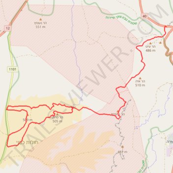
- Distance: 20.1 mi
- Elevation gain: 2,372 ft
- Maximum elevation: 1,808 ft
- Elevation loss: 2,372 ft
- Minimum elevation: 1,358 ft
- Moving time: 8 h 55 m
- Moving speed: 2.3 mph
- Maximum speed: 2.5 mph
- Total time: 8 h 55 m
- Global speed: 2.3 mph
Interactive trail map
Make a donation
Gear up for your next adventure:
As an Amazon Associate, this site earns from qualifying purchases at no extra cost to you.
Trail profile
- Distance: 20.1 mi
- Elevation gain: 2,372 ft
- Maximum elevation: 1,808 ft
- Elevation loss: 2,372 ft
- Minimum elevation: 1,358 ft
- Moving time: 8 h 55 m
- Moving speed: 2.3 mph
- Maximum speed: 2.5 mph
- Total time: 8 h 55 m
- Global speed: 2.3 mph
Make a donation
Gear up for your next adventure:
As an Amazon Associate, this site earns from qualifying purchases at no extra cost to you.
About this trail
Name: Har Ayt and Kasui Dunes trail, distance, elevation, map, profile, GPS track
Start: 40, Hevel Eilot Regional Council, Beersheba Subdistrict, South District, Israel (30.02095 35.05856)
End: 40, Hevel Eilot Regional Council, Beersheba Subdistrict, South District, Israel (30.02095 35.05856)
Coordinates: 29.96722 34.97593 30.02107 35.05856
Make a donation
Gear up for your next adventure:
As an Amazon Associate, this site earns from qualifying purchases at no extra cost to you.