Thank you for supporting this site ❤️
Make a donation
Make a donation
Gear up for your next adventure:
As an Amazon Associate, this site earns from qualifying purchases at no extra cost to you.
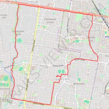
Stony Hill Creek and Melton loop
- Distance: 8.1 mi
- Elevation gain: 194 ft
- Maximum elevation: 443 ft
- Elevation loss: 194 ft
- Minimum elevation: 299 ft
- Moving time: 43 m 8 s
- Moving speed: 11.3 mph
- Maximum speed: 18.9 mph
- Total time: 57 m 4 s
- Global speed: 8.5 mph
Interactive trail map
Thank you for supporting this site ❤️
Make a donation
Make a donation
Gear up for your next adventure:
As an Amazon Associate, this site earns from qualifying purchases at no extra cost to you.
Trail profile
- Distance: 8.1 mi
- Elevation gain: 194 ft
- Maximum elevation: 443 ft
- Elevation loss: 194 ft
- Minimum elevation: 299 ft
- Moving time: 43 m 8 s
- Moving speed: 11.3 mph
- Maximum speed: 18.9 mph
- Total time: 57 m 4 s
- Global speed: 8.5 mph
Thank you for supporting this site ❤️
Make a donation
Make a donation
Gear up for your next adventure:
As an Amazon Associate, this site earns from qualifying purchases at no extra cost to you.
About this trail
Name: Stony Hill Creek and Melton loop trail, distance, elevation, map, profile, GPS track
Coordinates: -37.72357 144.73285 -37.69126 144.76800
Thank you for supporting this site ❤️
Make a donation
Make a donation
Gear up for your next adventure:
As an Amazon Associate, this site earns from qualifying purchases at no extra cost to you.