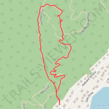
Cogswell Mine
- Distance: 1.2 mi
- Elevation gain: 154 ft
- Maximum elevation: 883 ft
- Elevation loss: 154 ft
- Minimum elevation: 728 ft
- Moving time: 35 m 56 s
- Moving speed: 2.0 mph
- Maximum speed: 4.5 mph
- Total time: 48 m 41 s
- Global speed: 1.5 mph
Interactive trail map
Trail profile
- Distance: 1.2 mi
- Elevation gain: 154 ft
- Maximum elevation: 883 ft
- Elevation loss: 154 ft
- Minimum elevation: 728 ft
- Moving time: 35 m 56 s
- Moving speed: 2.0 mph
- Maximum speed: 4.5 mph
- Total time: 48 m 41 s
- Global speed: 1.5 mph
About this trail
Name: Cogswell Mine trail, distance, elevation, map, profile, GPS track
Coordinates: 40.95988 -74.50481 40.96559 -74.50230
Topography: Morris County topographic map, elevation, terrain
Other hiking, mountain biking, running and outdoor activity trails
Click on a trail to view its statistics, map and profile.
Wildcat Ridge Wildlife Management Area - Lake Telemark Loop
United States > New Jersey > Morris County > Rockaway Township > Lake Telemark > Hibernia
Distance: 11.3 mi • Elevation gain: 1,214 ft • Maximum elevation: 942 ft
Wildcat Ridge Loop
United States > New Jersey > Morris County > Rockaway Township > Hibernia
Distance: 18.3 mi • Elevation gain: 2,018 ft • Maximum elevation: 1,024 ft
Wildcat Ridge Westie
United States > New Jersey > Morris County > Rockaway Township > Lake Telemark > Hibernia
Distance: 6.0 mi • Elevation gain: 732 ft • Maximum elevation: 942 ft