Nonpunglipancarpaniisan
Parcours créé sur Trace de Trail
- Distance: 0.3 mi
- Elevation gain: 213 ft
- Maximum elevation: 2,080 ft
- Elevation loss: 49 ft
- Minimum elevation: 1,864 ft
- Moving time: 3 m 24 s
- Moving speed: 5.1 mph
- Maximum speed: 10.5 mph
- Total time: 3 m 24 s
- Global speed: 5.1 mph
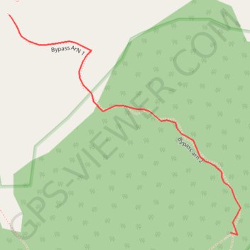
Interactive trail map
Trail profile
- Distance: 0.3 mi
- Elevation gain: 213 ft
- Maximum elevation: 2,080 ft
- Elevation loss: 49 ft
- Minimum elevation: 1,864 ft
- Moving time: 3 m 24 s
- Moving speed: 5.1 mph
- Maximum speed: 10.5 mph
- Total time: 3 m 24 s
- Global speed: 5.1 mph
About this trail
Name: Nonpunglipancarpaniisan trail, distance, elevation, map, profile, GPS track
Start: Bypass ArN 1, Babakan Madang, Bogor, West Java, Java, Indonesia (-6.59335 106.91631)
End: Bypass arn 2, Babakan Madang, Bogor, West Java, Java, Indonesia (-6.59559 106.91860)
Coordinates: -6.59561 106.91631 -6.59335 106.91870
Other hiking, mountain biking, running and outdoor activity trails
Click on a trail to view its statistics, map and profile.
Ciputat Market to Penginapan Pondok Indah Karang Potong
Indonesia > Banten > South Tangerang
Distance: 172.2 mi • Elevation gain: 16,273 ft • Maximum elevation: 2,592 ft