Thank you for supporting this site ❤️
Make a donation
Make a donation
Gear up for your next adventure:
As an Amazon Associate, this site earns from qualifying purchases at no extra cost to you.
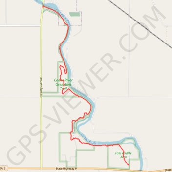
Cedar River Greenbelt Trail
- Distance: 4.2 mi
- Elevation gain: 243 ft
- Maximum elevation: 1,168 ft
- Elevation loss: 200 ft
- Minimum elevation: 1,076 ft
Interactive trail map
Thank you for supporting this site ❤️
Make a donation
Make a donation
Gear up for your next adventure:
As an Amazon Associate, this site earns from qualifying purchases at no extra cost to you.
Trail profile
- Distance: 4.2 mi
- Elevation gain: 243 ft
- Maximum elevation: 1,168 ft
- Elevation loss: 200 ft
- Minimum elevation: 1,076 ft
Thank you for supporting this site ❤️
Make a donation
Make a donation
Gear up for your next adventure:
As an Amazon Associate, this site earns from qualifying purchases at no extra cost to you.
About this trail
Name: Cedar River Greenbelt Trail trail, distance, elevation, map, profile, GPS track
Start: Junkyard Goat, Mitchell County, Iowa, 50461, United States (43.28467 -92.85552)
End: Cedar River Greenbelt, Mitchell, Mitchell County, Iowa, United States (43.31679 -92.87972)
Coordinates: 43.28467 -92.87972 43.31706 -92.85552
Topography: Mitchell County topographic map, elevation, terrain
Thank you for supporting this site ❤️
Make a donation
Make a donation
Gear up for your next adventure:
As an Amazon Associate, this site earns from qualifying purchases at no extra cost to you.