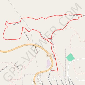
Osha Loop Trail in Lincoln National Forest
The Osha Loop Trail offers a delightful hiking experience with its blend of forested areas and stunning vistas. As you meander along the well-marked path, you'll be surrounded by tall conifers and perhaps catch sight of vibrant wildflowers during the summer months. The trail's moderate incline rewards hikers with breathtaking views of White Sands National Park and the Tularosa Basin, making it a perfect escape into nature. #Hiking #Mountain #Forest #Nature
- Distance: 2.5 mi
- Elevation gain: 456 ft
- Maximum elevation: 8,665 ft
- Elevation loss: 453 ft
- Minimum elevation: 8,435 ft
- Moving time: 1 h 3 m
- Moving speed: 2.4 mph
- Maximum speed: 5.1 mph
- Total time: 1 h 5 m
- Global speed: 2.3 mph
Interactive trail map
Trail profile
- Distance: 2.5 mi
- Elevation gain: 456 ft
- Maximum elevation: 8,665 ft
- Elevation loss: 453 ft
- Minimum elevation: 8,435 ft
- Moving time: 1 h 3 m
- Moving speed: 2.4 mph
- Maximum speed: 5.1 mph
- Total time: 1 h 5 m
- Global speed: 2.3 mph
About this trail
Name: Osha Loop Trail in Lincoln National Forest trail, distance, elevation, map, profile, GPS track
Start: Pines Alt, Otero County, New Mexico, 88317, United States (32.96142 -105.74551)
End: Pines Alt, Otero County, New Mexico, 88317, United States (32.96139 -105.74541)
Coordinates: 32.96131 -105.75262 32.96840 -105.74105
Topography: Otero County topographic map, elevation, terrain