Thank you for supporting this site ❤️
Make a donation
Make a donation
Gear up for your next adventure:
As an Amazon Associate, this site earns from qualifying purchases at no extra cost to you.
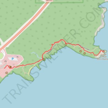
Shovel Point Trail
- Distance: 0.7 mi
- Elevation gain: 118 ft
- Maximum elevation: 702 ft
- Elevation loss: 190 ft
- Minimum elevation: 594 ft
- Moving time: 21 m 2 s
- Moving speed: 2.1 mph
- Maximum speed: 4.8 mph
- Total time: 30 m 31 s
- Global speed: 1.4 mph
Interactive trail map
Thank you for supporting this site ❤️
Make a donation
Make a donation
Gear up for your next adventure:
As an Amazon Associate, this site earns from qualifying purchases at no extra cost to you.
Trail profile
- Distance: 0.7 mi
- Elevation gain: 118 ft
- Maximum elevation: 702 ft
- Elevation loss: 190 ft
- Minimum elevation: 594 ft
- Moving time: 21 m 2 s
- Moving speed: 2.1 mph
- Maximum speed: 4.8 mph
- Total time: 30 m 31 s
- Global speed: 1.4 mph
Thank you for supporting this site ❤️
Make a donation
Make a donation
Gear up for your next adventure:
As an Amazon Associate, this site earns from qualifying purchases at no extra cost to you.
About this trail
Name: Shovel Point Trail trail, distance, elevation, map, profile, GPS track
End: Shovel Point Trail, Beaver Bay Township, Lake County, Minnesota, United States (47.33973 -91.18470)
Coordinates: 47.33838 -91.19603 47.34061 -91.18470
Topography: Lake County topographic map, elevation, terrain
Thank you for supporting this site ❤️
Make a donation
Make a donation
Gear up for your next adventure:
As an Amazon Associate, this site earns from qualifying purchases at no extra cost to you.