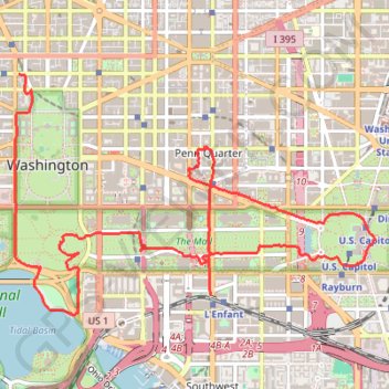
Washington DC
- Distance: 6.1 mi
- Elevation gain: 423 ft
- Maximum elevation: 131 ft
- Elevation loss: 502 ft
- Minimum elevation: -3 ft
- Moving time: 2 h 7 m
- Moving speed: 2.9 mph
- Maximum speed: 7.9 mph
- Total time: 3 h 6 m
- Global speed: 2.0 mph
Interactive trail map
Trail profile
- Distance: 6.1 mi
- Elevation gain: 423 ft
- Maximum elevation: 131 ft
- Elevation loss: 502 ft
- Minimum elevation: -3 ft
- Moving time: 2 h 7 m
- Moving speed: 2.9 mph
- Maximum speed: 7.9 mph
- Total time: 3 h 6 m
- Global speed: 2.0 mph
About this trail
Name: Washington DC trail, distance, elevation, map, profile, GPS track
Coordinates: 38.88460 -77.03942 38.90128 -77.00748
Topography: Washington topographic map, elevation, terrain
Other hiking, mountain biking, running and outdoor activity trails
Click on a trail to view its statistics, map and profile.
Washington DC's Monuments and Memorials Loop Walk
This loop walk offers a serene and reflective experience. Starting at the White House, you pass through the National Mall, observing landmarks such as the Washington Monument, World War II Memorial, and the Lincoln Memorial before circling the Tidal Basin to see memorials honoring Jefferson, Roosevelt, and…
Distance: 11.5 mi • Elevation gain: 627 ft • Maximum elevation: 157 ft
National Mall Loop
This loop walk is a scenic and enriching journey through Washington DC's most iconic landmarks. As you walk along the broad, tree-lined pathways, you'll encounter historic sites such as the Lincoln Memorial, the Washington Monument, and the Capitol Building, with numerous museums and memorials lining the way.…
Distance: 4.9 mi • Elevation gain: 223 ft • Maximum elevation: 52 ft
Tidal Basin, Jefferson Memorial, Hains Point and East Potomac Park Loop
This loop hike offers a serene escape enriched with picturesque views of cherry blossom trees, expansive vistas of the Potomac River, and significant landmarks like the Thomas Jefferson Memorial. This route is especially vibrant during the cherry blossom season and is ideal for leisurely strolls, making it a…
Distance: 6.0 mi • Elevation gain: 115 ft • Maximum elevation: 20 ft