Make a donation
Gear up for your next adventure:
As an Amazon Associate, this site earns from qualifying purchases at no extra cost to you.
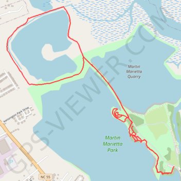
Explorer Trail, Dragonfly Trail, and Island Pond Loop in Martin Marietta Park
- Distance: 5.0 mi
- Elevation gain: 164 ft
- Maximum elevation: 20 ft
- Elevation loss: 164 ft
- Minimum elevation: -16 ft
- Moving time: 1 h 35 m
- Moving speed: 3.2 mph
- Maximum speed: 6.5 mph
- Total time: 1 h 36 m
- Global speed: 3.2 mph
Interactive trail map
Make a donation
Gear up for your next adventure:
As an Amazon Associate, this site earns from qualifying purchases at no extra cost to you.
Trail profile
- Distance: 5.0 mi
- Elevation gain: 164 ft
- Maximum elevation: 20 ft
- Elevation loss: 164 ft
- Minimum elevation: -16 ft
- Moving time: 1 h 35 m
- Moving speed: 3.2 mph
- Maximum speed: 6.5 mph
- Total time: 1 h 36 m
- Global speed: 3.2 mph
Make a donation
Gear up for your next adventure:
As an Amazon Associate, this site earns from qualifying purchases at no extra cost to you.
About this trail
Name: Explorer Trail, Dragonfly Trail, and Island Pond Loop in Martin Marietta Park trail, distance, elevation, map, profile, GPS track
Start: Explorer Trail, New Bern, Craven County, North Carolina, 28562, United States (35.13611 -77.08059)
End: Explorer Trail, New Bern, Craven County, North Carolina, 28562, United States (35.13590 -77.08072)
Coordinates: 35.13532 -77.10126 35.15226 -77.08059
Topography: New Bern topographic map, elevation, terrain
Make a donation
Gear up for your next adventure:
As an Amazon Associate, this site earns from qualifying purchases at no extra cost to you.