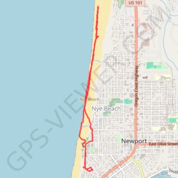
Thank you for supporting this site ❤️
Make a donation
Make a donation
Gear up for your next adventure:
As an Amazon Associate, this site earns from qualifying purchases at no extra cost to you.
Nye Beach
- Distance: 3.7 mi
- Elevation gain: 115 ft
- Maximum elevation: 92 ft
- Elevation loss: 121 ft
- Minimum elevation: 0 ft
- Moving time: 1 h 31 m
- Moving speed: 2.4 mph
- Maximum speed: 4.0 mph
- Total time: 1 h 33 m
- Global speed: 2.4 mph
Interactive trail map
Thank you for supporting this site ❤️
Make a donation
Make a donation
Gear up for your next adventure:
As an Amazon Associate, this site earns from qualifying purchases at no extra cost to you.
Trail profile
- Distance: 3.7 mi
- Elevation gain: 115 ft
- Maximum elevation: 92 ft
- Elevation loss: 121 ft
- Minimum elevation: 0 ft
- Moving time: 1 h 31 m
- Moving speed: 2.4 mph
- Maximum speed: 4.0 mph
- Total time: 1 h 33 m
- Global speed: 2.4 mph
Thank you for supporting this site ❤️
Make a donation
Make a donation
Gear up for your next adventure:
As an Amazon Associate, this site earns from qualifying purchases at no extra cost to you.
About this trail
Name: Nye Beach trail, distance, elevation, map, profile, GPS track
Coordinates: 44.63226 -124.06459 44.65616 -124.06065
Topography: Lincoln County topographic map, elevation, terrain
Thank you for supporting this site ❤️
Make a donation
Make a donation
Gear up for your next adventure:
As an Amazon Associate, this site earns from qualifying purchases at no extra cost to you.