Boardwalk Loop and Weston Lake Overlook in Congaree National Park
The Boardwalk Loop and Weston Lake Overlook offer a captivating journey through an old-growth forest, showcasing magnificent bald cypress trees and the distinctive "knees" that rise from the waterlogged soil. Along the route, visitors may observe a rich variety of wildlife, including turtles and diverse bird species, while the overlook provides a tranquil view of Weston Lake, enhancing the experience of this unique ecosystem. This hike is ideal for nature lovers seeking both serene landscapes and opportunities for wildlife observation. #Hiking #Loop #Lake #Forest #Nature
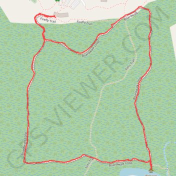
- Distance: 2.4 mi
- Elevation gain: 59 ft
- Maximum elevation: 141 ft
- Elevation loss: 59 ft
- Minimum elevation: 105 ft
- Moving time: 57 m 30 s
- Moving speed: 2.5 mph
- Maximum speed: 5.1 mph
- Total time: 1 h 6 m
- Global speed: 2.2 mph
Interactive trail map
Trail profile
- Distance: 2.4 mi
- Elevation gain: 59 ft
- Maximum elevation: 141 ft
- Elevation loss: 59 ft
- Minimum elevation: 105 ft
- Moving time: 57 m 30 s
- Moving speed: 2.5 mph
- Maximum speed: 5.1 mph
- Total time: 1 h 6 m
- Global speed: 2.2 mph
About this trail
Name: Boardwalk Loop and Weston Lake Overlook in Congaree National Park trail, distance, elevation, map, profile, GPS track
Start: Firefly Trail, Richland County, South Carolina, United States (33.82950 -80.82369)
End: Boardwalk Loop, Richland County, South Carolina, United States (33.82958 -80.82374)
Coordinates: 33.82172 -80.82565 33.83006 -80.81776
Topography: Richland County topographic map, elevation, terrain
Other hiking, mountain biking, running and outdoor activity trails
Click on a trail to view its statistics, map and profile.
Weston Lake Loop Trail in Congaree National Park
United States > South Carolina > Richland County
The Weston Lake Loop Trail offers a tranquil hiking experience through a lush old-growth forest. Along the route, you can expect to see towering hardwoods, such as oaks and cypress trees, alongside the tea-colored waters of Cedar Creek, which create a picturesque backdrop for nature lovers. The trail provides…
Distance: 4.9 mi • Elevation gain: 72 ft • Maximum elevation: 141 ft