Thank you for supporting this site ❤️
Make a donation
Make a donation
Gear up for your next adventure:
As an Amazon Associate, this site earns from qualifying purchases at no extra cost to you.
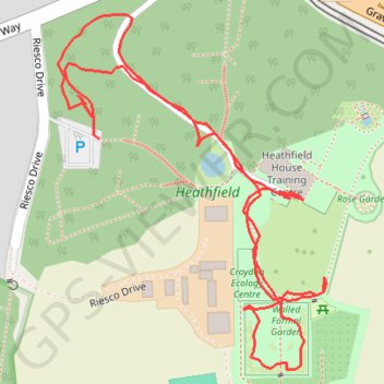
Heathfield
- Distance: 0.8 mi
- Elevation gain: 66 ft
- Maximum elevation: 479 ft
- Elevation loss: 72 ft
- Minimum elevation: 410 ft
- Moving time: 34 m 27 s
- Moving speed: 1.3 mph
- Maximum speed: 24.1 mph
- Total time: 40 m 46 s
- Global speed: 1.1 mph
Interactive trail map
Thank you for supporting this site ❤️
Make a donation
Make a donation
Gear up for your next adventure:
As an Amazon Associate, this site earns from qualifying purchases at no extra cost to you.
Trail profile
- Distance: 0.8 mi
- Elevation gain: 66 ft
- Maximum elevation: 479 ft
- Elevation loss: 72 ft
- Minimum elevation: 410 ft
- Moving time: 34 m 27 s
- Moving speed: 1.3 mph
- Maximum speed: 24.1 mph
- Total time: 40 m 46 s
- Global speed: 1.1 mph
Thank you for supporting this site ❤️
Make a donation
Make a donation
Gear up for your next adventure:
As an Amazon Associate, this site earns from qualifying purchases at no extra cost to you.
About this trail
Name: Heathfield trail, distance, elevation, map, profile, GPS track
Coordinates: 51.35569 -0.05863 51.35822 -0.05558
Thank you for supporting this site ❤️
Make a donation
Make a donation
Gear up for your next adventure:
As an Amazon Associate, this site earns from qualifying purchases at no extra cost to you.