Make a donation
Gear up for your next adventure:
As an Amazon Associate, this site earns from qualifying purchases at no extra cost to you.
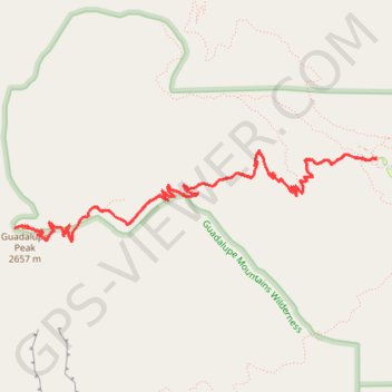
Guadalupe Peak Trail in Guadalupe Mountains National Park
Embarking on the Guadalupe Peak Trail promises a thrilling adventure for seasoned hikers. The journey begins with a challenging ascent marked by steep switchbacks, gradually revealing sweeping views of the rugged desert landscape and diverse mountain ecosystems. It's a trail that combines physical exertion with awe-inspiring natural beauty. The sense of achievement you feel upon reaching the summit, where you can soak in the expansive views from Texas's highest point, is simply unmatched—making this trail an absolute must for any hiking enthusiast. #Hiking #Mountain #Forest #Nature
- Distance: 8.3 mi
- Elevation gain: 3,419 ft
- Maximum elevation: 8,698 ft
- Elevation loss: 3,419 ft
- Minimum elevation: 5,850 ft
- Moving time: 4 h 38 m
- Moving speed: 1.8 mph
- Maximum speed: 3.5 mph
- Total time: 5 h 14 m
- Global speed: 1.6 mph
Interactive trail map
Make a donation
Gear up for your next adventure:
As an Amazon Associate, this site earns from qualifying purchases at no extra cost to you.
Trail profile
- Distance: 8.3 mi
- Elevation gain: 3,419 ft
- Maximum elevation: 8,698 ft
- Elevation loss: 3,419 ft
- Minimum elevation: 5,850 ft
- Moving time: 4 h 38 m
- Moving speed: 1.8 mph
- Maximum speed: 3.5 mph
- Total time: 5 h 14 m
- Global speed: 1.6 mph
Make a donation
Gear up for your next adventure:
As an Amazon Associate, this site earns from qualifying purchases at no extra cost to you.
About this trail
Name: Guadalupe Peak Trail in Guadalupe Mountains National Park trail, distance, elevation, map, profile, GPS track
Start: Guadalupe Peak Trail, Culberson County, Texas, 79847, United States (31.89664 -104.82829)
End: Guadalupe Peak Trail, Culberson County, Texas, 79847, United States (31.89667 -104.82824)
Coordinates: 31.89014 -104.86158 31.89738 -104.82824
Topography: Culberson County topographic map, elevation, terrain
Make a donation
Gear up for your next adventure:
As an Amazon Associate, this site earns from qualifying purchases at no extra cost to you.
Other hiking, mountain biking, running and outdoor activity trails
Click on a trail to view its statistics, map and profile.
Devil's Hall Trail in Guadalupe Mountains National Park
United States > Texas > Culberson County
The Devil's Hall Trail offers a delightful blend of adventure and stunning scenery! As you navigate the rocky terrain, you'll find yourself scrambling over boulders and encountering unique rock formations, making every step exciting. This trail is perfect for those looking for a moderately challenging hike…
Distance: 4.4 mi • Elevation gain: 974 ft • Maximum elevation: 6,539 ft