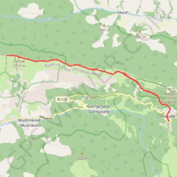
Prevalla - Oshlak Peak - Prevalla
- Distance: 10.3 mi
- Elevation gain: 2,795 ft
- Maximum elevation: 7,188 ft
- Elevation loss: 2,805 ft
- Minimum elevation: 4,951 ft
- Moving time: 5 h 6 m
- Moving speed: 2.0 mph
- Maximum speed: 8.2 mph
- Total time: 6 h 57 m
- Global speed: 1.5 mph
Interactive trail map
Trail profile
- Distance: 10.3 mi
- Elevation gain: 2,795 ft
- Maximum elevation: 7,188 ft
- Elevation loss: 2,805 ft
- Minimum elevation: 4,951 ft
- Moving time: 5 h 6 m
- Moving speed: 2.0 mph
- Maximum speed: 8.2 mph
- Total time: 6 h 57 m
- Global speed: 1.5 mph
About this trail
Name: Prevalla - Oshlak Peak - Prevalla trail, distance, elevation, map, profile, GPS track
Start: Pupëza, Prevallë, Municipality of Prizren, District of Prizren, Kosovo (42.17458 20.96211)
End: Pupëza, Prevallë, Municipality of Prizren, District of Prizren, Kosovo (42.17409 20.96214)
Coordinates: 42.17409 20.88605 42.19724 20.96306
Other hiking, mountain biking, running and outdoor activity trails
Click on a trail to view its statistics, map and profile.
2022_Yu
Slovenia > Ajdovščina > Žapuže
Distance: 1,526.9 mi • Elevation gain: 105,144 ft • Maximum elevation: 6,398 ft
Prevalla to Peskovi mountain peak to lake circuit - Gornja M...
Distance: 8.8 mi • Elevation gain: 3,950 ft • Maximum elevation: 8,629 ft