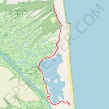
Gordons Pond Trail in Cape Henlopen State Park
Gordons Pond Trail offers a delightful experience for hikers and cyclists alike, winding through stunning salt marshes and providing breathtaking views of the surrounding wildlife. Along the route, you can expect to encounter diverse bird species, particularly during migration seasons, making it a haven for birdwatchers. The well-maintained path features both compact gravel and elevated boardwalk sections, allowing for smooth navigation while immersing yourself in the serene coastal environment. #Hiking #Lake #Forest #Nature #Sea #Atlantic #Ocean #Coast
- Distance: 6.4 mi
- Elevation gain: 121 ft
- Maximum elevation: 26 ft
- Elevation loss: 118 ft
- Minimum elevation: -10 ft
- Moving time: 2 h 16 m
- Moving speed: 2.8 mph
- Maximum speed: 3.7 mph
- Total time: 2 h 18 m
- Global speed: 2.8 mph
Interactive trail map
Trail profile
- Distance: 6.4 mi
- Elevation gain: 121 ft
- Maximum elevation: 26 ft
- Elevation loss: 118 ft
- Minimum elevation: -10 ft
- Moving time: 2 h 16 m
- Moving speed: 2.8 mph
- Maximum speed: 3.7 mph
- Total time: 2 h 18 m
- Global speed: 2.8 mph
About this trail
Name: Gordons Pond Trail in Cape Henlopen State Park trail, distance, elevation, map, profile, GPS track
Start: Ocean Drive, North Shores, Sussex County, Delaware, 19971, United States (38.74179 -75.08130)
End: Gordons Pond Trail, North Shores, Sussex County, Delaware, 19971, United States (38.74157 -75.08192)
Coordinates: 38.74155 -75.09430 38.77345 -75.08130
Topography: Sussex County topographic map, elevation, terrain
Other hiking, mountain biking, running and outdoor activity trails
Click on a trail to view its statistics, map and profile.
Gordons Pond Loop via Overlook and Beach in Cape Henlopen State Park
United States > Delaware > Sussex County
The Gordons Pond Loop offers a serene hiking experience through diverse landscapes, including picturesque salt marshes, tranquil wooded areas and the beach along the Atlantic Ocean. As you traverse the well-maintained trail, you can enjoy breathtaking views of the pond and the sea, watch for various bird…
Distance: 4.8 mi • Elevation gain: 79 ft • Maximum elevation: 30 ft