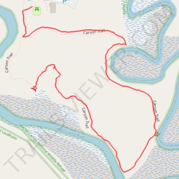
Carson Loop Trail
- Distance: 0.8 mi
- Elevation gain: 43 ft
- Maximum elevation: 39 ft
- Elevation loss: 30 ft
- Minimum elevation: 13 ft
- Moving time: 23 m 48 s
- Moving speed: 2.1 mph
- Maximum speed: 5.7 mph
- Total time: 34 m 11 s
- Global speed: 1.4 mph
Interactive trail map
Trail profile
- Distance: 0.8 mi
- Elevation gain: 43 ft
- Maximum elevation: 39 ft
- Elevation loss: 30 ft
- Minimum elevation: 13 ft
- Moving time: 23 m 48 s
- Moving speed: 2.1 mph
- Maximum speed: 5.7 mph
- Total time: 34 m 11 s
- Global speed: 1.4 mph
About this trail
Name: Carson Loop Trail trail, distance, elevation, map, profile, GPS track
Start: Carson Trail, Wells, York County, Maine, 04090, United States (43.34526 -70.54833)
End: Carson Trail, Wells, York County, Maine, 04090, United States (43.34708 -70.54839)
Coordinates: 43.34343 -70.54869 43.34708 -70.54464
Topography: York County topographic map, elevation, terrain