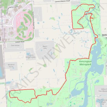
Kensington Metropark
- Distance: 12.5 mi
- Elevation gain: 659 ft
- Maximum elevation: 1,070 ft
- Elevation loss: 656 ft
- Minimum elevation: 883 ft
Interactive trail map
Trail profile
- Distance: 12.5 mi
- Elevation gain: 659 ft
- Maximum elevation: 1,070 ft
- Elevation loss: 656 ft
- Minimum elevation: 883 ft
About this trail
Name: Kensington Metropark trail, distance, elevation, map, profile, GPS track
Coordinates: 42.54005 -83.67092 42.57742 -83.62563
Topography: Oakland County topographic map, elevation, terrain