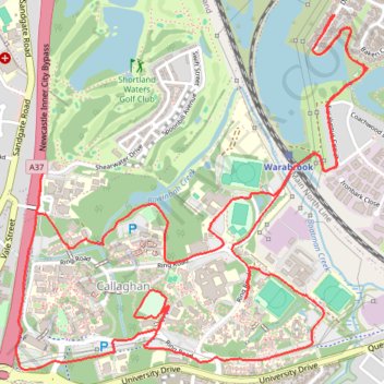
Callaghan loop
- Distance: 6.6 mi
- Elevation gain: 492 ft
- Maximum elevation: 148 ft
- Elevation loss: 489 ft
- Minimum elevation: 10 ft
- Moving time: 1 h 1 m
- Moving speed: 6.4 mph
- Maximum speed: 7.8 mph
- Total time: 1 h 1 m
- Global speed: 6.4 mph
Interactive trail map
Trail profile
- Distance: 6.6 mi
- Elevation gain: 492 ft
- Maximum elevation: 148 ft
- Elevation loss: 489 ft
- Minimum elevation: 10 ft
- Moving time: 1 h 1 m
- Moving speed: 6.4 mph
- Maximum speed: 7.8 mph
- Total time: 1 h 1 m
- Global speed: 6.4 mph
About this trail
Name: Callaghan loop trail, distance, elevation, map, profile, GPS track
Coordinates: -32.89651 151.69557 -32.88083 151.71409
Other hiking, mountain biking, running and outdoor activity trails
Click on a trail to view its statistics, map and profile.
Broadmeadow - Gulgong - Merrygoen - Dubbo railway
Australia > New South Wales > Newcastle
AU, NSW, railway
Distance: 232.6 mi • Elevation gain: 8,645 ft • Maximum elevation: 1,654 ft
Broadmeadow - Gulgong - Merrygoen - Dubbo railway
Australia > New South Wales > Newcastle
AU, NSW, railway
Distance: 233.2 mi • Elevation gain: 8,665 ft • Maximum elevation: 1,696 ft
University of Newcastle
Australia > New South Wales > Newcastle
Distance: 3.5 mi • Elevation gain: 302 ft • Maximum elevation: 144 ft
University Sidewalks
Australia > New South Wales > Newcastle
Distance: 3.5 mi • Elevation gain: 312 ft • Maximum elevation: 148 ft
Callaghan Loop Run
Australia > New South Wales > Newcastle
Distance: 3.6 mi • Elevation gain: 299 ft • Maximum elevation: 141 ft
Shortland Waters
Australia > New South Wales > Newcastle
Distance: 8.4 mi • Elevation gain: 577 ft • Maximum elevation: 98 ft
Warabrook run
Australia > New South Wales > Newcastle
Distance: 7.1 mi • Elevation gain: 482 ft • Maximum elevation: 223 ft