Make a donation
Gear up for your next adventure:
As an Amazon Associate, this site earns from qualifying purchases at no extra cost to you.
Otter Falls Trails
- Distance: 0.3 mi
- Elevation gain: 46 ft
- Maximum elevation: 1,768 ft
- Elevation loss: 95 ft
- Minimum elevation: 1,673 ft
- Moving time: 7 m 38 s
- Moving speed: 2.1 mph
- Maximum speed: 4.2 mph
- Total time: 9 m 3 s
- Global speed: 1.8 mph
Interactive trail map
Make a donation
Gear up for your next adventure:
As an Amazon Associate, this site earns from qualifying purchases at no extra cost to you.
Trail profile
- Distance: 0.3 mi
- Elevation gain: 46 ft
- Maximum elevation: 1,768 ft
- Elevation loss: 95 ft
- Minimum elevation: 1,673 ft
- Moving time: 7 m 38 s
- Moving speed: 2.1 mph
- Maximum speed: 4.2 mph
- Total time: 9 m 3 s
- Global speed: 1.8 mph
Make a donation
Gear up for your next adventure:
As an Amazon Associate, this site earns from qualifying purchases at no extra cost to you.
About this trail
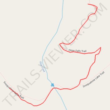
Name: Otter Falls Trails trail, distance, elevation, map, profile, GPS track
Start: Otter Falls Trail, King County, Washington, United States (47.58695 -121.46739)
End: Snoqualmie Lake Trail, King County, Washington, United States (47.58563 -121.46922)
Coordinates: 47.58535 -121.46922 47.58695 -121.46709
Topography: King County topographic map, elevation, terrain
Make a donation
Gear up for your next adventure:
As an Amazon Associate, this site earns from qualifying purchases at no extra cost to you.
Other hiking, mountain biking, running and outdoor activity trails
Click on a trail to view its statistics, map and profile.
Northern part of the Pacific Crest Trail (PCT)
United States > Oregon > Klamath County
Hike on the Pacific Crest National Scenic Trail from Crater Lake to Canada Border through Oregon and Washington along the Sierra Nevada and Cascade mountain ranges. #Hiking #Mountain #SierraNevada #Cascade #Nature #Forest #Park #PCT
Distance: 744.6 mi • Elevation gain: 145,367 ft • Maximum elevation: 7,569 ft
Taylor River Trail to Otter Falls
United States > Washington > King County
Distance: 9.1 mi • Elevation gain: 1,273 ft • Maximum elevation: 1,814 ft