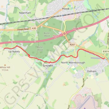
Basingstoke Canal from Up Nately to Odiham; near Hook, England
- Distance: 4.8 mi
- Elevation gain: 177 ft
- Maximum elevation: 367 ft
- Elevation loss: 184 ft
- Minimum elevation: 246 ft
- Moving time: 2 h 15 m
- Moving speed: 2.1 mph
- Maximum speed: 6.1 mph
- Total time: 3 h 39 m
- Global speed: 1.3 mph
Interactive trail map
Trail profile
- Distance: 4.8 mi
- Elevation gain: 177 ft
- Maximum elevation: 367 ft
- Elevation loss: 184 ft
- Minimum elevation: 246 ft
- Moving time: 2 h 15 m
- Moving speed: 2.1 mph
- Maximum speed: 6.1 mph
- Total time: 3 h 39 m
- Global speed: 1.3 mph
About this trail
Name: Basingstoke Canal from Up Nately to Odiham; near Hook, England trail, distance, elevation, map, profile, GPS track
Coordinates: 51.25722 -1.00583 51.26540 -0.92962