Thank you for supporting this site ❤️
Make a donation
Make a donation
Gear up for your next adventure:
As an Amazon Associate, this site earns from qualifying purchases at no extra cost to you.
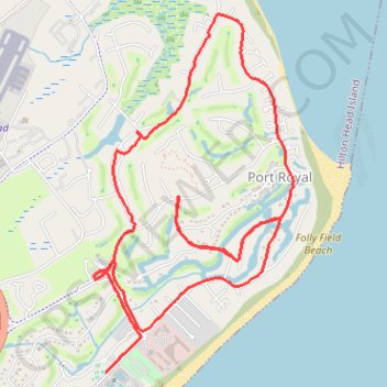
Island Club run
- Distance: 7.4 mi
- Elevation gain: 154 ft
- Maximum elevation: 39 ft
- Elevation loss: 154 ft
- Minimum elevation: 7 ft
- Moving time: 1 h 4 m
- Moving speed: 6.9 mph
- Maximum speed: 9.8 mph
- Total time: 1 h 4 m
- Global speed: 6.9 mph
Interactive trail map
Thank you for supporting this site ❤️
Make a donation
Make a donation
Gear up for your next adventure:
As an Amazon Associate, this site earns from qualifying purchases at no extra cost to you.
Trail profile
- Distance: 7.4 mi
- Elevation gain: 154 ft
- Maximum elevation: 39 ft
- Elevation loss: 154 ft
- Minimum elevation: 7 ft
- Moving time: 1 h 4 m
- Moving speed: 6.9 mph
- Maximum speed: 9.8 mph
- Total time: 1 h 4 m
- Global speed: 6.9 mph
Thank you for supporting this site ❤️
Make a donation
Make a donation
Gear up for your next adventure:
As an Amazon Associate, this site earns from qualifying purchases at no extra cost to you.
About this trail
Name: Island Club run trail, distance, elevation, map, profile, GPS track
Coordinates: 32.20707 -80.68758 32.23201 -80.67113
Topography: Beaufort County topographic map, elevation, terrain
Thank you for supporting this site ❤️
Make a donation
Make a donation
Gear up for your next adventure:
As an Amazon Associate, this site earns from qualifying purchases at no extra cost to you.