Thank you for supporting this site ❤️
Make a donation
Make a donation
Gear up for your next adventure:
As an Amazon Associate, this site earns from qualifying purchases at no extra cost to you.
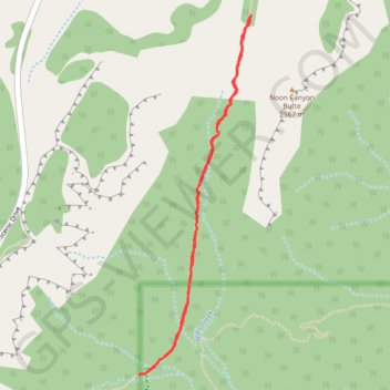
Bryce Canyon National Park Under the Rim
BCNP
- Distance: 2.8 mi
- Elevation gain: 502 ft
- Maximum elevation: 8,186 ft
- Elevation loss: 502 ft
- Minimum elevation: 7,740 ft
- Moving time: 1 h 36 m
- Moving speed: 1.8 mph
- Maximum speed: 3.2 mph
- Total time: 2 h 9 m
- Global speed: 1.3 mph
Interactive trail map
Thank you for supporting this site ❤️
Make a donation
Make a donation
Gear up for your next adventure:
As an Amazon Associate, this site earns from qualifying purchases at no extra cost to you.
Trail profile
- Distance: 2.8 mi
- Elevation gain: 502 ft
- Maximum elevation: 8,186 ft
- Elevation loss: 502 ft
- Minimum elevation: 7,740 ft
- Moving time: 1 h 36 m
- Moving speed: 1.8 mph
- Maximum speed: 3.2 mph
- Total time: 2 h 9 m
- Global speed: 1.3 mph
Thank you for supporting this site ❤️
Make a donation
Make a donation
Gear up for your next adventure:
As an Amazon Associate, this site earns from qualifying purchases at no extra cost to you.
About this trail
Name: Bryce Canyon National Park Under the Rim trail, distance, elevation, map, profile, GPS track
Start: Under-the-Rim Trail, Garfield County, Utah, United States (37.55708 -112.23108)
Coordinates: 37.53979 -112.23785 37.55720 -112.23097
Topography: Garfield County topographic map, elevation, terrain
Thank you for supporting this site ❤️
Make a donation
Make a donation
Gear up for your next adventure:
As an Amazon Associate, this site earns from qualifying purchases at no extra cost to you.