Thank you for supporting this site ❤️
Make a donation
Make a donation
Gear up for your next adventure:
As an Amazon Associate, this site earns from qualifying purchases at no extra cost to you.
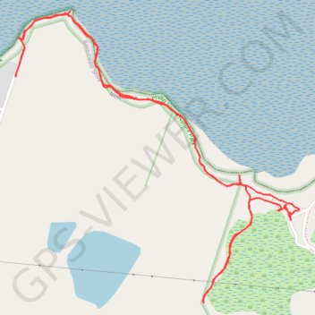
Fishers wetlands
Phillip Island Nature Park
- Distance: 2.4 mi
- Elevation gain: 98 ft
- Maximum elevation: 46 ft
- Elevation loss: 98 ft
- Minimum elevation: 0 ft
- Moving time: 34 m 13 s
- Moving speed: 4.2 mph
- Maximum speed: 8.8 mph
- Total time: 39 m 11 s
- Global speed: 3.7 mph
Interactive trail map
Thank you for supporting this site ❤️
Make a donation
Make a donation
Gear up for your next adventure:
As an Amazon Associate, this site earns from qualifying purchases at no extra cost to you.
Trail profile
- Distance: 2.4 mi
- Elevation gain: 98 ft
- Maximum elevation: 46 ft
- Elevation loss: 98 ft
- Minimum elevation: 0 ft
- Moving time: 34 m 13 s
- Moving speed: 4.2 mph
- Maximum speed: 8.8 mph
- Total time: 39 m 11 s
- Global speed: 3.7 mph
Thank you for supporting this site ❤️
Make a donation
Make a donation
Gear up for your next adventure:
As an Amazon Associate, this site earns from qualifying purchases at no extra cost to you.
About this trail
Name: Fishers wetlands trail, distance, elevation, map, profile, GPS track
Start: Newhaven, Bass Coast Shire, Victoria, 3925, Australia (-38.51090 145.34090)
End: Newhaven, Bass Coast Shire, Victoria, 3925, Australia (-38.51090 145.34089)
Coordinates: -38.51328 145.33077 -38.50490 145.34122
Thank you for supporting this site ❤️
Make a donation
Make a donation
Gear up for your next adventure:
As an Amazon Associate, this site earns from qualifying purchases at no extra cost to you.
Other hiking, mountain biking, running and outdoor activity trails
Click on a trail to view its statistics, map and profile.