Red Butes and Old Wagon Trails
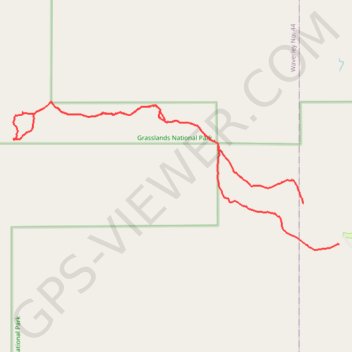
Grasslands National Park
- Distance: 10.3 mi
- Elevation gain: 669 ft
- Maximum elevation: 3,009 ft
- Elevation loss: 781 ft
- Minimum elevation: 2,776 ft
- Moving time: 3 h 34 m
- Moving speed: 2.9 mph
- Maximum speed: 3.7 mph
- Total time: 4 h 29 m
- Global speed: 2.3 mph
Interactive trail map
Trail profile
- Distance: 10.3 mi
- Elevation gain: 669 ft
- Maximum elevation: 3,009 ft
- Elevation loss: 781 ft
- Minimum elevation: 2,776 ft
- Moving time: 3 h 34 m
- Moving speed: 2.9 mph
- Maximum speed: 3.7 mph
- Total time: 4 h 29 m
- Global speed: 2.3 mph
About this trail
Name: Red Butes and Old Wagon Trails trail, distance, elevation, map, profile, GPS track
Start: Red Butes Trail, Old Post No. 43, Saskatchewan, Canada (49.07657 -106.53999)
End: Old Wagon trail, Old Post No. 43, Saskatchewan, Canada (49.06947 -106.53066)
Coordinates: 49.06833 -106.61820 49.09442 -106.53032