Thank you for supporting this site ❤️
Make a donation
Make a donation
Gear up for your next adventure:
As an Amazon Associate, this site earns from qualifying purchases at no extra cost to you.
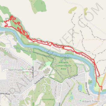
Deans Bank Track in Dublin Bay-Outlet-Albert Town Recreation Reserve, Wanaka
- Distance: 7.1 mi
- Elevation gain: 791 ft
- Maximum elevation: 1,132 ft
- Elevation loss: 768 ft
- Minimum elevation: 922 ft
- Moving time: 2 h 49 m
- Moving speed: 2.5 mph
- Maximum speed: 4.7 mph
- Total time: 2 h 57 m
- Global speed: 2.4 mph
Interactive trail map
Thank you for supporting this site ❤️
Make a donation
Make a donation
Gear up for your next adventure:
As an Amazon Associate, this site earns from qualifying purchases at no extra cost to you.
Trail profile
- Distance: 7.1 mi
- Elevation gain: 791 ft
- Maximum elevation: 1,132 ft
- Elevation loss: 768 ft
- Minimum elevation: 922 ft
- Moving time: 2 h 49 m
- Moving speed: 2.5 mph
- Maximum speed: 4.7 mph
- Total time: 2 h 57 m
- Global speed: 2.4 mph
Thank you for supporting this site ❤️
Make a donation
Make a donation
Gear up for your next adventure:
As an Amazon Associate, this site earns from qualifying purchases at no extra cost to you.
About this trail
Name: Deans Bank Track in Dublin Bay-Outlet-Albert Town Recreation Reserve, Wanaka trail, distance, elevation, map, profile, GPS track
Coordinates: -44.68030 169.15399 -44.65997 169.19156
Thank you for supporting this site ❤️
Make a donation
Make a donation
Gear up for your next adventure:
As an Amazon Associate, this site earns from qualifying purchases at no extra cost to you.
Other hiking, mountain biking, running and outdoor activity trails
Click on a trail to view its statistics, map and profile.