Walkley Heights Reserve
- Distance: 2.9 mi
- Elevation gain: 213 ft
- Maximum elevation: 240 ft
- Elevation loss: 210 ft
- Minimum elevation: 164 ft
- Moving time: 55 m 39 s
- Moving speed: 3.1 mph
- Maximum speed: 5.3 mph
- Total time: 1 h 5 m
- Global speed: 2.6 mph
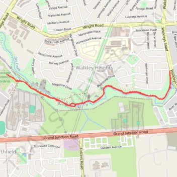
Interactive trail map
Trail profile
- Distance: 2.9 mi
- Elevation gain: 213 ft
- Maximum elevation: 240 ft
- Elevation loss: 210 ft
- Minimum elevation: 164 ft
- Moving time: 55 m 39 s
- Moving speed: 3.1 mph
- Maximum speed: 5.3 mph
- Total time: 1 h 5 m
- Global speed: 2.6 mph
About this trail
Name: Walkley Heights Reserve trail, distance, elevation, map, profile, GPS track
Coordinates: -34.84397 138.62649 -34.84039 138.64619
Other hiking, mountain biking, running and outdoor activity trails
Click on a trail to view its statistics, map and profile.
Walkley Heights Reserve
Australia > South Australia > Adelaide
Distance: 4.5 mi • Elevation gain: 305 ft • Maximum elevation: 315 ft
Dry Creek Trail
Australia > South Australia > Adelaide
Distance: 14.0 mi • Elevation gain: 863 ft • Maximum elevation: 669 ft