SMTR 16 KM
Route created on plotaroute.com
- Distance: 10.0 mi
- Elevation gain: 3,658 ft
- Maximum elevation: 1,365 ft
- Elevation loss: 3,642 ft
- Minimum elevation: 13 ft
- Moving time: 1 h 35 m
- Moving speed: 6.3 mph
- Maximum speed: 16.2 mph
- Total time: 1 h 35 m
- Global speed: 6.3 mph
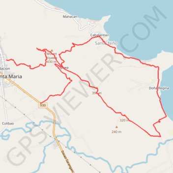
Interactive trail map
Trail profile
- Distance: 10.0 mi
- Elevation gain: 3,658 ft
- Maximum elevation: 1,365 ft
- Elevation loss: 3,642 ft
- Minimum elevation: 13 ft
- Moving time: 1 h 35 m
- Moving speed: 6.3 mph
- Maximum speed: 16.2 mph
- Total time: 1 h 35 m
- Global speed: 6.3 mph
About this trail
Name: SMTR 16 KM trail, distance, elevation, map, profile, GPS track
Start: Poblacion, Santa Maria, Davao Occidental, Davao Region, 8011, Philippines (6.55516 125.47412)
Coordinates: 6.53554 125.47412 6.56119 125.51521