Thank you for supporting this site ❤️
Make a donation
Make a donation
Gear up for your next adventure:
As an Amazon Associate, this site earns from qualifying purchases at no extra cost to you.
2026_04_11T21_31_58Z
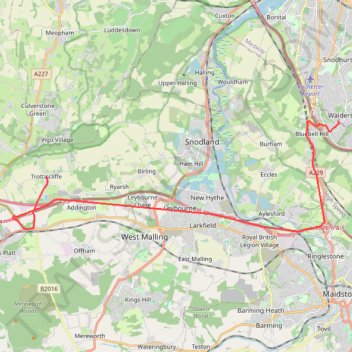
- Distance: 13.9 mi
- Elevation gain: 899 ft
- Maximum elevation: 604 ft
- Elevation loss: 702 ft
- Minimum elevation: 23 ft
Interactive trail map
Thank you for supporting this site ❤️
Make a donation
Make a donation
Gear up for your next adventure:
As an Amazon Associate, this site earns from qualifying purchases at no extra cost to you.
Trail profile
- Distance: 13.9 mi
- Elevation gain: 899 ft
- Maximum elevation: 604 ft
- Elevation loss: 702 ft
- Minimum elevation: 23 ft
Thank you for supporting this site ❤️
Make a donation
Make a donation
Gear up for your next adventure:
As an Amazon Associate, this site earns from qualifying purchases at no extra cost to you.
About this trail
Name: 2026_04_11T21_31_58Z trail, distance, elevation, map, profile, GPS track
Coordinates: 51.29718 0.33377 51.33716 0.52163
Thank you for supporting this site ❤️
Make a donation
Make a donation
Gear up for your next adventure:
As an Amazon Associate, this site earns from qualifying purchases at no extra cost to you.
Other hiking, mountain biking, running and outdoor activity trails
Click on a trail to view its statistics, map and profile.
2026_04_14T12_19_50Z
United Kingdom > England > Medway > Chatham
Distance: 8.3 mi • Elevation gain: 558 ft • Maximum elevation: 564 ft