Thank you for supporting this site ❤️
Make a donation
Make a donation
Gear up for your next adventure:
As an Amazon Associate, this site earns from qualifying purchases at no extra cost to you.
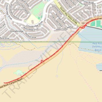
Red Rock Legacy Trail
- Distance: 2.4 mi
- Elevation gain: 128 ft
- Maximum elevation: 3,337 ft
- Elevation loss: 135 ft
- Minimum elevation: 3,212 ft
- Moving time: 45 m 14 s
- Moving speed: 3.2 mph
- Maximum speed: 6.0 mph
- Total time: 45 m 14 s
- Global speed: 3.2 mph
Interactive trail map
Thank you for supporting this site ❤️
Make a donation
Make a donation
Gear up for your next adventure:
As an Amazon Associate, this site earns from qualifying purchases at no extra cost to you.
Trail profile
- Distance: 2.4 mi
- Elevation gain: 128 ft
- Maximum elevation: 3,337 ft
- Elevation loss: 135 ft
- Minimum elevation: 3,212 ft
- Moving time: 45 m 14 s
- Moving speed: 3.2 mph
- Maximum speed: 6.0 mph
- Total time: 45 m 14 s
- Global speed: 3.2 mph
Thank you for supporting this site ❤️
Make a donation
Make a donation
Gear up for your next adventure:
As an Amazon Associate, this site earns from qualifying purchases at no extra cost to you.
About this trail
Name: Red Rock Legacy Trail trail, distance, elevation, map, profile, GPS track
Coordinates: 36.14926 -115.37504 36.15879 -115.35771
Topography: Las Vegas topographic map, elevation, terrain
Thank you for supporting this site ❤️
Make a donation
Make a donation
Gear up for your next adventure:
As an Amazon Associate, this site earns from qualifying purchases at no extra cost to you.
Other hiking, mountain biking, running and outdoor activity trails
Click on a trail to view its statistics, map and profile.
Brownstone Canyon via Summerlin Stonebridge
United States > Nevada > Clark County > Las Vegas
Distance: 10.2 mi • Elevation gain: 1,732 ft • Maximum elevation: 4,961 ft