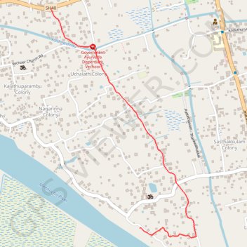
Vechoor
- Distance: 1.3 mi
- Elevation gain: 16 ft
- Maximum elevation: 23 ft
- Elevation loss: 7 ft
- Minimum elevation: 10 ft
- Moving time: 6 m 16 s
- Moving speed: 12.7 mph
- Maximum speed: 23.2 mph
- Total time: 6 m 54 s
- Global speed: 11.5 mph
Interactive trail map
Trail profile
- Distance: 1.3 mi
- Elevation gain: 16 ft
- Maximum elevation: 23 ft
- Elevation loss: 7 ft
- Minimum elevation: 10 ft
- Moving time: 6 m 16 s
- Moving speed: 12.7 mph
- Maximum speed: 23.2 mph
- Total time: 6 m 54 s
- Global speed: 11.5 mph
About this trail
Name: Vechoor trail, distance, elevation, map, profile, GPS track
Start: Lakshamveedu Colony, Vaikom, Kottayam, Kerala, 686144, India (9.65948 76.41791)
Coordinates: 9.65898 76.41310 9.67111 76.42096