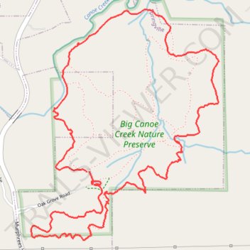
Big Canoe Creek Nature Preserve Loop Trail
- Distance: 4.6 mi
- Elevation gain: 682 ft
- Maximum elevation: 994 ft
- Elevation loss: 686 ft
- Minimum elevation: 663 ft
- Moving time: 2 h 15 m
- Moving speed: 2.1 mph
- Maximum speed: 4.5 mph
- Total time: 2 h 31 m
- Global speed: 1.8 mph
Interactive trail map
Trail profile
- Distance: 4.6 mi
- Elevation gain: 682 ft
- Maximum elevation: 994 ft
- Elevation loss: 686 ft
- Minimum elevation: 663 ft
- Moving time: 2 h 15 m
- Moving speed: 2.1 mph
- Maximum speed: 4.5 mph
- Total time: 2 h 31 m
- Global speed: 1.8 mph
About this trail
Name: Big Canoe Creek Nature Preserve Loop Trail trail, distance, elevation, map, profile, GPS track
Start: Creek Loop Trail, Springville, St. Clair County, Alabama, 35146, United States (33.79591 -86.48301)
End: Creek Loop Trail, Springville, St. Clair County, Alabama, 35146, United States (33.79593 -86.48281)
Coordinates: 33.79162 -86.48718 33.80608 -86.47307
Topography: St. Clair County topographic map, elevation, terrain
Other hiking, mountain biking, running and outdoor activity trails
Click on a trail to view its statistics, map and profile.
Big Canoe Creek Nature Preserve Loop Walk
United States > Alabama > St. Clair County > Springville
Distance: 2.7 mi • Elevation gain: 256 ft • Maximum elevation: 883 ft
Big Canoe Creek Nature Preserve
United States > Alabama > St. Clair County > Springville
Distance: 1.7 mi • Elevation gain: 220 ft • Maximum elevation: 883 ft