Phoenix
- Distance: 2.1 mi
- Elevation gain: 125 ft
- Maximum elevation: 1,188 ft
- Elevation loss: 95 ft
- Minimum elevation: 1,112 ft
Interactive trail map
Trail profile
- Distance: 2.1 mi
- Elevation gain: 125 ft
- Maximum elevation: 1,188 ft
- Elevation loss: 95 ft
- Minimum elevation: 1,112 ft
About this trail
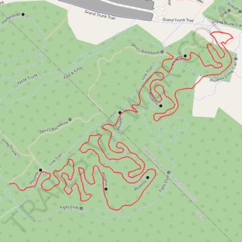
Name: Phoenix trail, distance, elevation, map, profile, GPS track
Coordinates: 43.58914 -80.26707 43.59308 -80.26023
Other hiking, mountain biking, running and outdoor activity trails
Click on a trail to view its statistics, map and profile.
Paths and trails in Guelph
Distance: 12.4 mi • Elevation gain: 436 ft • Maximum elevation: 1,201 ft
Ontario country roads
Distance: 93.4 mi • Elevation gain: 3,730 ft • Maximum elevation: 1,631 ft
Phoenix MTB Trail
Distance: 2.1 mi • Elevation gain: 115 ft • Maximum elevation: 1,184 ft