Thank you for supporting this site ❤️
Make a donation
Make a donation
Gear up for your next adventure:
As an Amazon Associate, this site earns from qualifying purchases at no extra cost to you.
Vandalens Peak Loop
- Distance: 11.0 mi
- Elevation gain: 3,012 ft
- Maximum elevation: 3,012 ft
- Elevation loss: 3,012 ft
- Minimum elevation: 853 ft
- Moving time: 2 h 55 m
- Moving speed: 3.8 mph
- Maximum speed: 8.3 mph
- Total time: 2 h 59 m
- Global speed: 3.7 mph
Interactive trail map
Thank you for supporting this site ❤️
Make a donation
Make a donation
Gear up for your next adventure:
As an Amazon Associate, this site earns from qualifying purchases at no extra cost to you.
Trail profile
- Distance: 11.0 mi
- Elevation gain: 3,012 ft
- Maximum elevation: 3,012 ft
- Elevation loss: 3,012 ft
- Minimum elevation: 853 ft
- Moving time: 2 h 55 m
- Moving speed: 3.8 mph
- Maximum speed: 8.3 mph
- Total time: 2 h 59 m
- Global speed: 3.7 mph
Thank you for supporting this site ❤️
Make a donation
Make a donation
Gear up for your next adventure:
As an Amazon Associate, this site earns from qualifying purchases at no extra cost to you.
About this trail
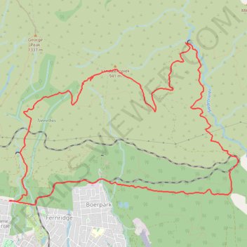
Name: Vandalens Peak Loop trail, distance, elevation, map, profile, GPS track
Coordinates: -33.94070 22.45732 -33.91325 22.50389
Thank you for supporting this site ❤️
Make a donation
Make a donation
Gear up for your next adventure:
As an Amazon Associate, this site earns from qualifying purchases at no extra cost to you.