Thank you for supporting this site ❤️
Make a donation
Make a donation
Gear up for your next adventure:
As an Amazon Associate, this site earns from qualifying purchases at no extra cost to you.
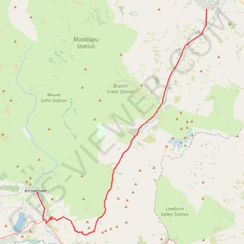
Arrowton - Wanaka
#Bike
- Distance: 32.7 mi
- Elevation gain: 2,825 ft
- Maximum elevation: 3,550 ft
- Elevation loss: 3,061 ft
- Minimum elevation: 1,106 ft
Interactive trail map
Thank you for supporting this site ❤️
Make a donation
Make a donation
Gear up for your next adventure:
As an Amazon Associate, this site earns from qualifying purchases at no extra cost to you.
Trail profile
- Distance: 32.7 mi
- Elevation gain: 2,825 ft
- Maximum elevation: 3,550 ft
- Elevation loss: 3,061 ft
- Minimum elevation: 1,106 ft
Thank you for supporting this site ❤️
Make a donation
Make a donation
Gear up for your next adventure:
As an Amazon Associate, this site earns from qualifying purchases at no extra cost to you.
About this trail
Name: Arrowton - Wanaka trail, distance, elevation, map, profile, GPS track
Coordinates: -44.99582 168.83877 -44.71411 169.13697
Thank you for supporting this site ❤️
Make a donation
Make a donation
Gear up for your next adventure:
As an Amazon Associate, this site earns from qualifying purchases at no extra cost to you.
Other hiking, mountain biking, running and outdoor activity trails
Click on a trail to view its statistics, map and profile.