Thank you for supporting this site ❤️
Make a donation
Make a donation
Gear up for your next adventure:
As an Amazon Associate, this site earns from qualifying purchases at no extra cost to you.
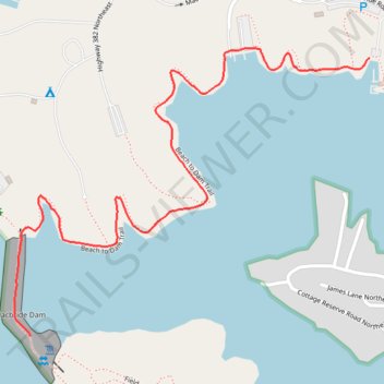
Lake Macbride Beach to Dam Trail
- Distance: 1.3 mi
- Elevation gain: 128 ft
- Maximum elevation: 764 ft
- Elevation loss: 161 ft
- Minimum elevation: 699 ft
- Moving time: 27 m 9 s
- Moving speed: 2.9 mph
- Maximum speed: 3.8 mph
- Total time: 27 m 9 s
- Global speed: 2.9 mph
Interactive trail map
Thank you for supporting this site ❤️
Make a donation
Make a donation
Gear up for your next adventure:
As an Amazon Associate, this site earns from qualifying purchases at no extra cost to you.
Trail profile
- Distance: 1.3 mi
- Elevation gain: 128 ft
- Maximum elevation: 764 ft
- Elevation loss: 161 ft
- Minimum elevation: 699 ft
- Moving time: 27 m 9 s
- Moving speed: 2.9 mph
- Maximum speed: 3.8 mph
- Total time: 27 m 9 s
- Global speed: 2.9 mph
Thank you for supporting this site ❤️
Make a donation
Make a donation
Gear up for your next adventure:
As an Amazon Associate, this site earns from qualifying purchases at no extra cost to you.
About this trail
Name: Lake Macbride Beach to Dam Trail trail, distance, elevation, map, profile, GPS track
Coordinates: 41.79271 -91.57533 41.79889 -91.56511
Topography: Johnson County topographic map, elevation, terrain
Thank you for supporting this site ❤️
Make a donation
Make a donation
Gear up for your next adventure:
As an Amazon Associate, this site earns from qualifying purchases at no extra cost to you.
Other hiking, mountain biking, running and outdoor activity trails
Click on a trail to view its statistics, map and profile.
Iowa City Track Me
United States > Iowa > Johnson County > Iowa City
Distance: 16.1 mi • Elevation gain: 623 ft • Maximum elevation: 850 ft