Thank you for supporting this site ❤️
Make a donation
Make a donation
Gear up for your next adventure:
As an Amazon Associate, this site earns from qualifying purchases at no extra cost to you.
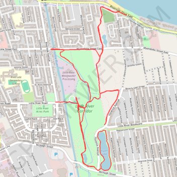
Little River Corridor
- Distance: 6.6 mi
- Elevation gain: 69 ft
- Maximum elevation: 594 ft
- Elevation loss: 69 ft
- Minimum elevation: 574 ft
- Moving time: 47 m 51 s
- Moving speed: 8.3 mph
- Maximum speed: 18.2 mph
- Total time: 49 m 59 s
- Global speed: 8.0 mph
Interactive trail map
Thank you for supporting this site ❤️
Make a donation
Make a donation
Gear up for your next adventure:
As an Amazon Associate, this site earns from qualifying purchases at no extra cost to you.
Trail profile
- Distance: 6.6 mi
- Elevation gain: 69 ft
- Maximum elevation: 594 ft
- Elevation loss: 69 ft
- Minimum elevation: 574 ft
- Moving time: 47 m 51 s
- Moving speed: 8.3 mph
- Maximum speed: 18.2 mph
- Total time: 49 m 59 s
- Global speed: 8.0 mph
Thank you for supporting this site ❤️
Make a donation
Make a donation
Gear up for your next adventure:
As an Amazon Associate, this site earns from qualifying purchases at no extra cost to you.
About this trail
Name: Little River Corridor trail, distance, elevation, map, profile, GPS track
Start: Ganatchio Trail, Windsor, Ontario, N8S 0A1, Canada (42.32644 -82.92513)
End: 8555, Little River Road, Windsor, Ontario, N8S 2B5, Canada (42.32732 -82.92887)
Coordinates: 42.31936 -82.92963 42.33845 -82.91766
Thank you for supporting this site ❤️
Make a donation
Make a donation
Gear up for your next adventure:
As an Amazon Associate, this site earns from qualifying purchases at no extra cost to you.