St Edmund Way 20 (Stratford St Mary, via Dedham to Manningtree)
- Distance: 12.1 mi
- Elevation gain: 604 ft
- Maximum elevation: 161 ft
- Elevation loss: 597 ft
- Minimum elevation: -3 ft
- Moving time: 4 h 55 m
- Moving speed: 2.5 mph
- Maximum speed: 8.2 mph
- Total time: 6 h 20 m
- Global speed: 1.9 mph
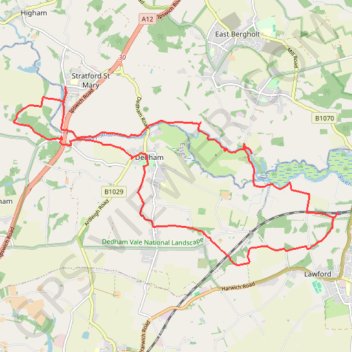
Interactive trail map
Trail profile
- Distance: 12.1 mi
- Elevation gain: 604 ft
- Maximum elevation: 161 ft
- Elevation loss: 597 ft
- Minimum elevation: -3 ft
- Moving time: 4 h 55 m
- Moving speed: 2.5 mph
- Maximum speed: 8.2 mph
- Total time: 6 h 20 m
- Global speed: 1.9 mph
About this trail
Name: St Edmund Way 20 (Stratford St Mary, via Dedham to Manningtree) trail, distance, elevation, map, profile, GPS track
Start: Station Road, Lawford, Tendring, Essex, England, CO11 2LE, United Kingdom (51.94841 1.04390)
End: Station Road, Lawford, Tendring, Essex, England, CO11 2LE, United Kingdom (51.94884 1.04497)
Coordinates: 51.94062 0.95856 51.96973 1.04497