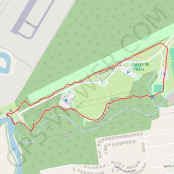
Thank you for supporting this site ❤️
Make a donation
Make a donation
Gear up for your next adventure:
As an Amazon Associate, this site earns from qualifying purchases at no extra cost to you.
Creekside loop
Creekside Park Loop
- Distance: 1.9 mi
- Elevation gain: 16 ft
- Maximum elevation: 20 ft
- Elevation loss: 16 ft
- Minimum elevation: 3 ft
- Moving time: 33 m 24 s
- Moving speed: 3.4 mph
- Maximum speed: 4.2 mph
- Total time: 34 m 24 s
- Global speed: 3.3 mph
Interactive trail map
Thank you for supporting this site ❤️
Make a donation
Make a donation
Gear up for your next adventure:
As an Amazon Associate, this site earns from qualifying purchases at no extra cost to you.
Trail profile
- Distance: 1.9 mi
- Elevation gain: 16 ft
- Maximum elevation: 20 ft
- Elevation loss: 16 ft
- Minimum elevation: 3 ft
- Moving time: 33 m 24 s
- Moving speed: 3.4 mph
- Maximum speed: 4.2 mph
- Total time: 34 m 24 s
- Global speed: 3.3 mph
Thank you for supporting this site ❤️
Make a donation
Make a donation
Gear up for your next adventure:
As an Amazon Associate, this site earns from qualifying purchases at no extra cost to you.
About this trail
Name: Creekside loop trail, distance, elevation, map, profile, GPS track
Coordinates: 35.05856 -77.04938 35.06403 -77.03715
Topography: Craven County topographic map, elevation, terrain
Thank you for supporting this site ❤️
Make a donation
Make a donation
Gear up for your next adventure:
As an Amazon Associate, this site earns from qualifying purchases at no extra cost to you.