GGF24 MF FINAL
- Distance: 63.4 mi
- Elevation gain: 8,465 ft
- Maximum elevation: 2,572 ft
- Elevation loss: 8,468 ft
- Minimum elevation: 148 ft
Interactive trail map
Trail profile
- Distance: 63.4 mi
- Elevation gain: 8,465 ft
- Maximum elevation: 2,572 ft
- Elevation loss: 8,468 ft
- Minimum elevation: 148 ft
About this trail
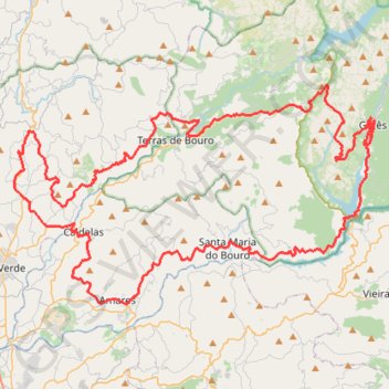
Name: GGF24 MF FINAL trail, distance, elevation, map, profile, GPS track
Coordinates: 41.62780 -8.42665 41.74960 -8.16164
Other hiking, mountain biking, running and outdoor activity trails
Click on a trail to view its statistics, map and profile.
Estrada Nacional 2 'Faro a Chaves' (EN2) Traçado Completo
Toda esta EN 2 é uma manta de "patchwork", com uma variedade de relevos e paisagens, gentes e culturas, incomparável com qualquer outra Estrada de Portugal. Cruza alguns dos mais importantes rios de Portugal e Ibéricos, com destaque, nomeadamente, para o Mondego e o Zêzere, para o Tejo e o Douro. Várias…
Distance: 445.7 mi • Elevation gain: 32,766 ft • Maximum elevation: 3,199 ft
Percorrer a Estrada N2 (Chaves - Faro)
Distance: 451.4 mi • Elevation gain: 34,570 ft • Maximum elevation: 3,202 ft
Estrada Nacional 2 de Faro a Chaves (Traçado Completo)
Distance: 446.8 mi • Elevation gain: 36,745 ft • Maximum elevation: 3,209 ft
Camino Portugues Central
Portugal > Lisbon > Lisbon > Madalena
Lissabon - Porto: 347 km<br> Porto - Santiago: 242 km<br><br><a href="https://www.santiago.nl/product-categorie/gidsen/gidsen-portugal/">Gids</a><br>
Distance: 375.5 mi • Elevation gain: 27,198 ft • Maximum elevation: 1,542 ft
Percorrer a Estrada N2 (Chaves - Faro)
Distance: 451.4 mi • Elevation gain: 34,646 ft • Maximum elevation: 3,192 ft
EuroVelo 1 (Por
Portugal > Viana do Castelo > Caminha > Terreiro
Distance: 718.6 mi • Elevation gain: 35,509 ft • Maximum elevation: 833 ft
Percorrer a Estrada N2 (Chaves - Faro)
Distance: 451.4 mi • Elevation gain: 34,646 ft • Maximum elevation: 3,192 ft
Percorrer a Estrada N2 (Chaves - Faro)
Distance: 451.4 mi • Elevation gain: 34,646 ft • Maximum elevation: 3,192 ft
Southern section — European Divide Trail
France > Auvergne-Rhône-Alpes > Drôme > Valence
Distance: 1,506.1 mi • Elevation gain: 139,026 ft • Maximum elevation: 6,578 ft
Percorrer a Estrada N2 (Chaves - Faro)
https://en-hk.gps-viewer.com/track-xhw5k/Percorrer-a-Estrada-N2-Chaves-Faro/
Distance: 451.4 mi • Elevation gain: 34,570 ft • Maximum elevation: 3,202 ft