Theo Fulton Park, Hunters Ridge Park and Fine Park loop along Grand River
- Distance: 7.8 mi
- Elevation gain: 233 ft
- Maximum elevation: 883 ft
- Elevation loss: 233 ft
- Minimum elevation: 837 ft
- Moving time: 1 h 25 m
- Moving speed: 5.5 mph
- Maximum speed: 14.9 mph
- Total time: 1 h 42 m
- Global speed: 4.6 mph
Interactive trail map
Trail profile
- Distance: 7.8 mi
- Elevation gain: 233 ft
- Maximum elevation: 883 ft
- Elevation loss: 233 ft
- Minimum elevation: 837 ft
- Moving time: 1 h 25 m
- Moving speed: 5.5 mph
- Maximum speed: 14.9 mph
- Total time: 1 h 42 m
- Global speed: 4.6 mph
About this trail
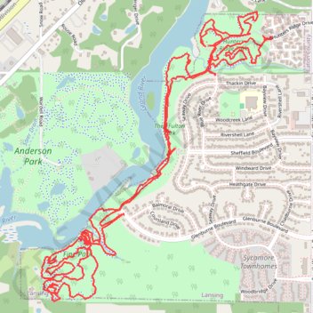
Name: Theo Fulton Park, Hunters Ridge Park and Fine Park loop along Grand River trail, distance, elevation, map, profile, GPS track
Coordinates: 42.68539 -84.62273 42.70075 -84.60611
Topography: Lansing topographic map, elevation, terrain
Other hiking, mountain biking, running and outdoor activity trails
Click on a trail to view its statistics, map and profile.
Lansing West Lansing Trail Ryan's Loop
United States > Michigan > Eaton County > Lansing
Distance: 1.9 mi • Elevation gain: 33 ft • Maximum elevation: 873 ft
West Lansing Trail Ryan's Loop
United States > Michigan > Eaton County > Lansing
Distance: 1.1 mi • Elevation gain: 3 ft • Maximum elevation: 873 ft
Anderson Park new Green
United States > Michigan > Eaton County
Distance: 1.1 mi • Elevation gain: 36 ft • Maximum elevation: 876 ft