Hewitt Farm Trails
- Distance: 1.6 mi
- Elevation gain: 154 ft
- Maximum elevation: 272 ft
- Elevation loss: 154 ft
- Minimum elevation: 144 ft
- Moving time: 42 m 2 s
- Moving speed: 2.2 mph
- Maximum speed: 3.5 mph
- Total time: 57 m 39 s
- Global speed: 1.6 mph
Interactive trail map
Trail profile
- Distance: 1.6 mi
- Elevation gain: 154 ft
- Maximum elevation: 272 ft
- Elevation loss: 154 ft
- Minimum elevation: 144 ft
- Moving time: 42 m 2 s
- Moving speed: 2.2 mph
- Maximum speed: 3.5 mph
- Total time: 57 m 39 s
- Global speed: 1.6 mph
About this trail
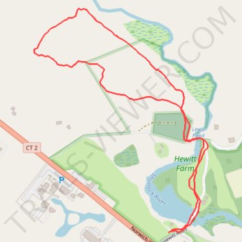
Name: Hewitt Farm Trails trail, distance, elevation, map, profile, GPS track
Coordinates: 41.44648 -71.89802 41.45326 -71.89100
Topography: Southeastern Connecticut Planning Region topographic map, elevation, terrain