Thank you for supporting this site ❤️
Make a donation
Make a donation
Gear up for your next adventure:
As an Amazon Associate, this site earns from qualifying purchases at no extra cost to you.
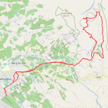
Groenberg Loop
- Distance: 18.8 mi
- Elevation gain: 2,260 ft
- Maximum elevation: 1,476 ft
- Elevation loss: 2,224 ft
- Minimum elevation: 433 ft
- Moving time: 1 h 52 m
- Moving speed: 10.0 mph
- Maximum speed: 29.9 mph
- Total time: 1 h 54 m
- Global speed: 9.9 mph
Interactive trail map
Thank you for supporting this site ❤️
Make a donation
Make a donation
Gear up for your next adventure:
As an Amazon Associate, this site earns from qualifying purchases at no extra cost to you.
Trail profile
- Distance: 18.8 mi
- Elevation gain: 2,260 ft
- Maximum elevation: 1,476 ft
- Elevation loss: 2,224 ft
- Minimum elevation: 433 ft
- Moving time: 1 h 52 m
- Moving speed: 10.0 mph
- Maximum speed: 29.9 mph
- Total time: 1 h 54 m
- Global speed: 9.9 mph
Thank you for supporting this site ❤️
Make a donation
Make a donation
Gear up for your next adventure:
As an Amazon Associate, this site earns from qualifying purchases at no extra cost to you.
About this trail
Name: Groenberg Loop trail, distance, elevation, map, profile, GPS track
Coordinates: -33.65465 19.01018 -33.59795 19.09096
Thank you for supporting this site ❤️
Make a donation
Make a donation
Gear up for your next adventure:
As an Amazon Associate, this site earns from qualifying purchases at no extra cost to you.