
Great Southern Rail Trail (GSRT) from Loch to Korumburra
- Distance: 20.2 mi
- Elevation gain: 1,444 ft
- Maximum elevation: 761 ft
- Elevation loss: 1,444 ft
- Minimum elevation: 299 ft
- Moving time: 2 h 41 s
- Moving speed: 10.0 mph
- Maximum speed: 21.3 mph
- Total time: 2 h 35 m
- Global speed: 7.8 mph
Interactive trail map
Trail profile
- Distance: 20.2 mi
- Elevation gain: 1,444 ft
- Maximum elevation: 761 ft
- Elevation loss: 1,444 ft
- Minimum elevation: 299 ft
- Moving time: 2 h 41 s
- Moving speed: 10.0 mph
- Maximum speed: 21.3 mph
- Total time: 2 h 35 m
- Global speed: 7.8 mph
About this trail
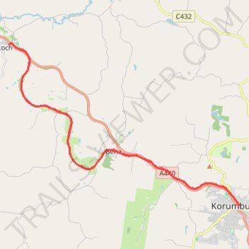
Name: Great Southern Rail Trail (GSRT) from Loch to Korumburra trail, distance, elevation, map, profile, GPS track
Start: Speight Street, Loch, Shire of South Gippsland, Victoria, 3945, Australia (-38.36827 145.70902)
End: Speight Street, Loch, Shire of South Gippsland, Victoria, 3945, Australia (-38.36822 145.70898)
Coordinates: -38.43201 145.70895 -38.36808 145.82500