Make a donation
Gear up for your next adventure:
As an Amazon Associate, this site earns from qualifying purchases at no extra cost to you.
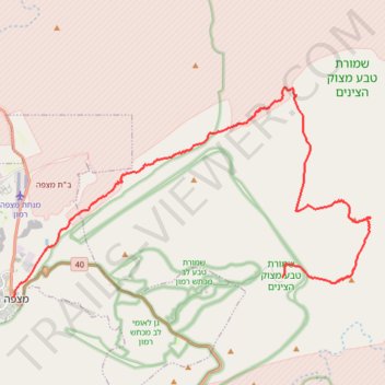
Mount Ardon to Mitzpe Ramon
הר ארדון למצפה רמון: מעלה מחמל וקו פנורמי ארוך מעל מכתש רמון
- Distance: 20.4 mi
- Elevation gain: 3,209 ft
- Maximum elevation: 2,759 ft
- Elevation loss: 1,883 ft
- Minimum elevation: 1,299 ft
- Moving time: 9 h 21 m
- Moving speed: 2.2 mph
- Maximum speed: 2.6 mph
- Total time: 9 h 21 m
- Global speed: 2.2 mph
Interactive trail map
Make a donation
Gear up for your next adventure:
As an Amazon Associate, this site earns from qualifying purchases at no extra cost to you.
Trail profile
- Distance: 20.4 mi
- Elevation gain: 3,209 ft
- Maximum elevation: 2,759 ft
- Elevation loss: 1,883 ft
- Minimum elevation: 1,299 ft
- Moving time: 9 h 21 m
- Moving speed: 2.2 mph
- Maximum speed: 2.6 mph
- Total time: 9 h 21 m
- Global speed: 2.2 mph
Make a donation
Gear up for your next adventure:
As an Amazon Associate, this site earns from qualifying purchases at no extra cost to you.
About this trail
Name: Mount Ardon to Mitzpe Ramon trail, distance, elevation, map, profile, GPS track
Coordinates: 30.61228 34.80513 30.68972 34.95793
Make a donation
Gear up for your next adventure:
As an Amazon Associate, this site earns from qualifying purchases at no extra cost to you.
Other hiking, mountain biking, running and outdoor activity trails
Click on a trail to view its statistics, map and profile.
Ramon to Sapir
Israel > South District > Ramat Negev Regional Council
מכתש רמון לספיר: ריצה חוצה מדבריות: מהר הנגב אל הערבה
Distance: 22.5 mi • Elevation gain: 2,808 ft • Maximum elevation: 1,795 ft