Thank you for supporting this site ❤️
Make a donation
Make a donation
Gear up for your next adventure:
As an Amazon Associate, this site earns from qualifying purchases at no extra cost to you.
Marietta Mine Bandit Trails Double Track
- Distance: 3.7 mi
- Elevation gain: 184 ft
- Maximum elevation: 482 ft
- Elevation loss: 180 ft
- Minimum elevation: 381 ft
- Moving time: 48 m 24 s
- Moving speed: 4.6 mph
- Maximum speed: 17.6 mph
- Total time: 56 m 5 s
- Global speed: 4.0 mph
Interactive trail map
Thank you for supporting this site ❤️
Make a donation
Make a donation
Gear up for your next adventure:
As an Amazon Associate, this site earns from qualifying purchases at no extra cost to you.
Trail profile
- Distance: 3.7 mi
- Elevation gain: 184 ft
- Maximum elevation: 482 ft
- Elevation loss: 180 ft
- Minimum elevation: 381 ft
- Moving time: 48 m 24 s
- Moving speed: 4.6 mph
- Maximum speed: 17.6 mph
- Total time: 56 m 5 s
- Global speed: 4.0 mph
Thank you for supporting this site ❤️
Make a donation
Make a donation
Gear up for your next adventure:
As an Amazon Associate, this site earns from qualifying purchases at no extra cost to you.
About this trail
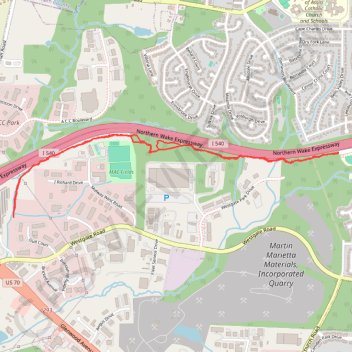
Name: Marietta Mine Bandit Trails Double Track trail, distance, elevation, map, profile, GPS track
Coordinates: 35.90481 -78.76438 35.91030 -78.73767
Topography: Raleigh topographic map, elevation, terrain
Thank you for supporting this site ❤️
Make a donation
Make a donation
Gear up for your next adventure:
As an Amazon Associate, this site earns from qualifying purchases at no extra cost to you.